
COURSES
104km – 75km – 54km – 40km – 18km – 10km
WHAT ARE COURSES?
hike or trail run or ultra trail run
GET TO KNOW YOUR TRAIL
Check out what every trail prepared for you!
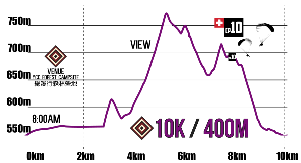

| FT18 | distance (km) | split (km) | altitude (m.a.s.l.) | cumulative + from start (m) | cumulative – from start (m) | cumulative + split (m) | cumulative – split (m) | cut time |
|---|---|---|---|---|---|---|---|---|
| start | 0 | 0 | 530 | 0 | 0 | 0 | 0 | 8:00am start |
| 8 | 6 | 690 | 360 | -210 | 360 | -210 | ||
| cpV = venue | 10.5 | 2.8 | 520 | 360 | -380 | 0 | -170 | 10:45 DNF or change to 10km |
| TOP | 13.5 | 1.7 | 830 | 670 | -380 | 310 | 0 | |
| turn right – bridge | 15.5 | 2.1 | 2.1 | 690 | -620 | 20 | -240 | |
| finish | 18.5 | 3.3 | 3.3 | 690 | -690 | 0 | -70 |

To ensure participant safety and event suitability, the following experience requirements are in place for the longer distance races:
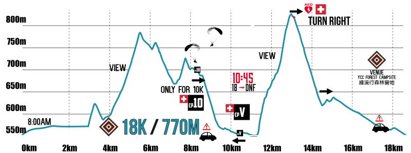
| FT40 | distance (km) | split (km) | altitude (m.a.s.l.) | cumulative + from start (m) | cumulative – from start (m) | cumulative + split (m) | cumulative – split (m) | cut time |
|---|---|---|---|---|---|---|---|---|
| start | 0 | 0 | 530 | 0 | 0 | 0 | 0 | 5:30am start |
| X | 10.5 | 10.5 | 1640 | 1250 | -110 | 1250 | -110 | |
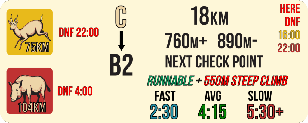
| cpA | 13.4 | 2.9 | 1520 | 1330 | -350 | 80 | -240 | 10:15am DNF |
| X | 16.3 | 2.9 | 1550 | 1570 | -430 | 240 | -80 | |
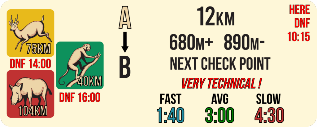
| Y | 22.6 | 6.3 | 1550 | 1990 | -960 | 420 | -530 | |
| cpB | 24.9 | 2.3 | 1310 | 2010 | -1240 | 20 | -280 | 16:00 40k→DNF |
| Y | 27.2 | 2.3 | 1550 | 2290 | -1260 | 280 | -20 | |
| finish | 38.8 | 11.6 | 530 | 2340 | -2340 | 50 | -1080 | <18:30 |

To ensure participant safety and event suitability, the following experience requirements are in place for the longer distance races:

To ensure participant safety and event suitability, the following experience requirements are in place for the longer distance races:
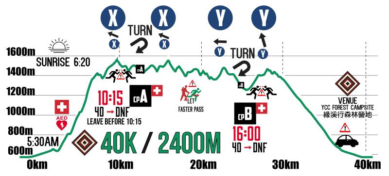
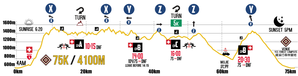
| FT75 | distance (km) | split (km) | altitude (m.a.s.l.) | cumulative + from start (m) | cumulative – from start (m) | cumulative + split (m) | cumulative – split (m) | cut time |
|---|---|---|---|---|---|---|---|---|
| start | 0 | 0 | 530 | 0 | 0 | 0 | 0 | 4am start |
| X | 10.5 | 10.5 | 1640 | 1250 | -110 | 1250 | -110 | |
| cpA | 13.4 | 2.9 | 1520 | 1330 | -350 | 80 | -240 | 8:15 DNF |
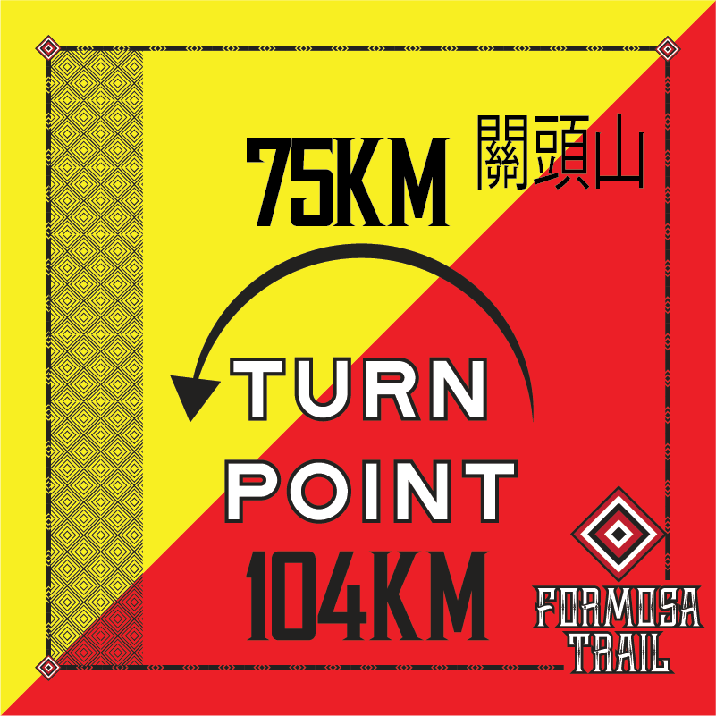
| turn point ↶ | 18.1 | 4.7 | 1535 | 1580 | -540 | 250 | -190 | |
| cpA | 22.8 | 4.7 | 1520 | 1770 | -790 | 190 | -250 | 10:15 DNF |
| X | 25.6 | 2.8 | 1640 | 2010 | -870 | 240 | -80 | |
| Y | 31.9 | 6.3 | 1550 | 2430 | -1400 | 420 | -530 | |
| cpB | 34.2 | 2.3 | 1310 | 2450 | -1680 | 20 | -280 | 14:00 DNF |
| Z | 40 | 5.8 | 1470 | 2830 | -1920 | 380 | -240 | |
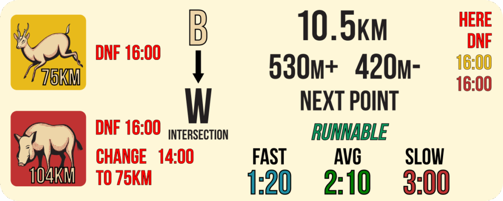
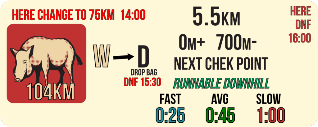
| W (intersectin near cpC) | 44.6 | 4.6 | 1410 | 2980 | -2100 | 150 | -180 | 16:00 75k→DNF |
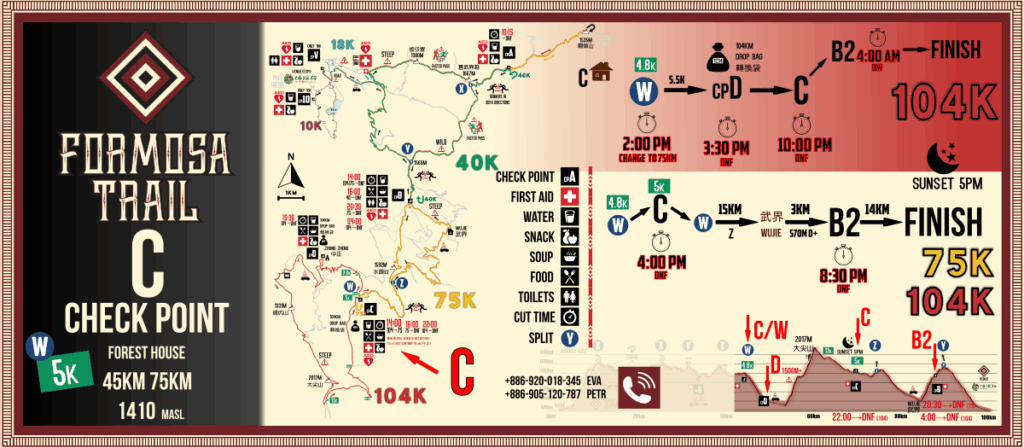
| cpC | 44.8 | 4.8 | 1420 | 2980 | -2100 | 150 | -180 | 16:00 75k→DNF |
| Z | 49.6 | 4.8 | 1470 | 3150 | -2250 | 170 | -150 | |
| Wujie | 59.4 | 9.8 | 760 | 3200 | -2990 | 50 | -740 | |
| cpB2 | 62.6 | 3.2 | 1310 | 3750 | -2990 | 550 | 0 | 20:30 75k→DNF |
| Y | 64.9 | 2.3 | 1550 | 4030 | -3010 | 280 | -20 | |
| finish | 76.5 | 11.6 | 530 | 4090 | -4090 | 60 | -1080 | <24:00 |

To ensure participant safety and event suitability, the following experience requirements are in place for the longer distance races:
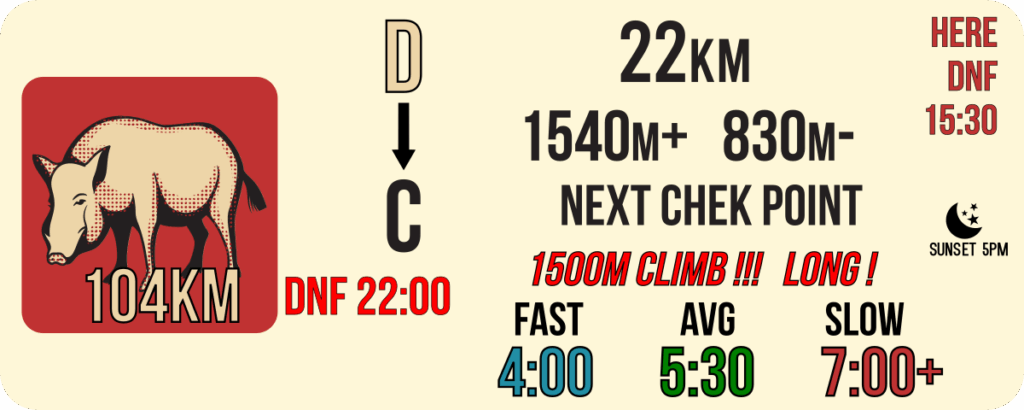
Drop Bag for 104km Participants
During race pack collection, 104km participants will receive one white bag with your BIB number clearly written on it for their drop bag intended for Checkpoint D.
Before the race start, you must deposit your designated cpD drop bag in the marked “drop bag cpD” area at the starting point, near the finisher arch.
These drop bags will be available at cpD from 10:00 AM onwards and will be transported back to the race venue after 11:30 PM on Saturday.
You are responsible for collecting your drop bag from the venue by 10:00 AM on Sunday. Any uncollected bags after this time may be disposed of or reused by the organizers. If you withdraw (DNF) at cpD, you will be able to retrieve your drop bag there.
Please be aware that the race organizers are not responsible for any loss or damage to the contents of your drop bag. We strongly advise against placing valuable items in these bags.
Remember that there is specific mandatory equipment required for the entire course (including a headlamp, jacket, whistle, phone with a Taiwan operator SIM card, space blanket, etc.).
You can use your drop bag at this check point to prepare snacks for the rest of the course. However, we do not recommend storing fresh food such as rice bowls or sandwiches, as they may spoil in the heat.
What to consider including in your drop bag? The section ahead involves a significant 1500m of vertical ascent, and you will be heading into the night, where temperatures may drop:

We are pleased to inform you that the 2025 Formosa Trail 104km has been selected as a qualifying race for the 2027 Western States 100. Runners who complete the race within 28 hours will qualify to enter a lottery where the runners for Western States will be selected. You do not need to submit anything to us; we will obtain the results directly from your website.
The qualifying period for the 2027 Western States will be from November 3, 2025 through November 1, 2026. The lottery will be held on December 5, 2026, and the race itself will be run on June 26-27, 2027.
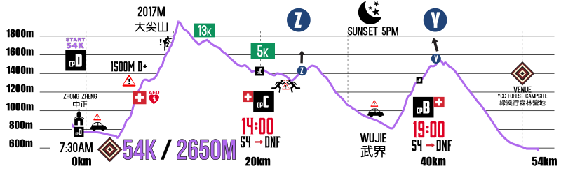
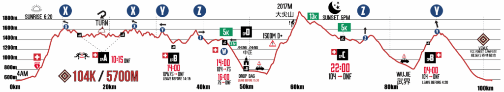
| FT104 | distance (km) | split (km) | altitude (m.a.s.l.) | cumulative + from start (m) | cumulative – from start (m) | cumulative + split (m) | cumulative – split (m) | cut time |
|---|---|---|---|---|---|---|---|---|
| start | 0.0 | 0 | 530 | 0 | 0 | 0 | 0 | 4am start |
| X | 10.5 | 10.5 | 1640 | 1250 | -110 | 1250 | -110 | |
| cpA | 13.4 | 2.9 | 1520 | 1330 | -350 | 80 | -240 | 8:15 DNF |
| turn point ↶ | 18.1 | 4.7 | 1535 | 1580 | -540 | 250 | -190 | |
| cpA | 22.8 | 4.7 | 1520 | 1770 | -790 | 190 | -250 | 10:15 DNF |
| X | 25.6 | 2.8 | 1640 | 2010 | -870 | 240 | -80 | |
| Y | 31.9 | 6.3 | 1550 | 2430 | -1400 | 420 | -530 | |
| cpB | 34.2 | 2.3 | 1310 | 2450 | -1680 | 20 | -280 | 14:00 DNF |
| Z | 40.0 | 5.8 | 1470 | 2830 | -1920 | 380 | -240 | |
| W (intersectin near cpC) | 44.6 | 4.6 | 1410 | 2980 | -2100 | 150 | -180 | 14:00(14:30) 104→75k 16:00 104k/75k→DNF 104km is not detour to cpC1 |
| cpD Zhong Zheng | 50.0 | 5.2 | 710 | 2980 | -2800 | 0 | -700 | DROP BAG 15:30 DNF (leave before) |
| trail entry | 54.3 | 4.3 | 645 | 3000 | -2880 | 20 | -80 | |
| 大尖山 2017m | 61.5 | 7.2 | 2017 | 4420 | -2950 | 1420 | -70 | |
| cpC2 | 71.8 | 10.3 | 1410 | 4520 | -3630 | 100 | -680 | 22:00 104k→DNF |
| Z | 76.6 | 4.8 | 1470 | 4700 | -3780 | 180 | -150 | |
| Wujie | 86.4 | 9.8 | 760 | 4730 | -4520 | 30 | -740 | |
| cpB2 | 89.6 | 3.2 | 1310 | 5280 | -4520 | 550 | 0 | 04:00 104k→DNF |
| Y | 91.9 | 2.3 | 1550 | 5560 | -4540 | 280 | -20 | |
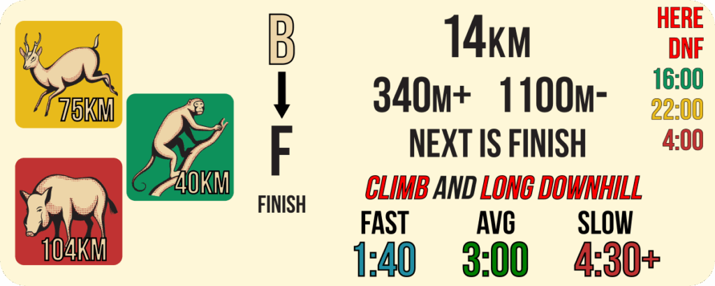
| finish | 103.5 | 11.6 | 530 | 5620 | -5620 | 60 | -1080 | <08:00am |
Formosa Trail COURSES MAP
practical map of all courses and basic information
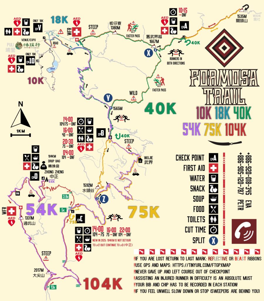
.gpx files DOWNLOAD
Formosa Trail EVENT GOOGLE MAP
Online Google map with most important locations
full screen online map: https://tinyurl.com/FTonlineMAP
Categories & Awards
FINISHER
Every finisher will receive a special finisher’s gift, which is often a practical item rather than a medal.
AWARDS
Awards will be presented to the top finishers in the following categories:
- 104km & 75km: First 5 male and first 5 female finishers. The awards ceremony will be held on Sunday morning.
- 54km: First 5 male and first 5 female finishers. The awards ceremony will be held on Saturday evening.
- 40km & 18km: First 5 male and first 5 female finishers. The awards ceremony will be held on Saturday afternoon.
- 10km: The 10km is an activity for hiking and running. While we do record and publish finisher times, this category does not have awards.
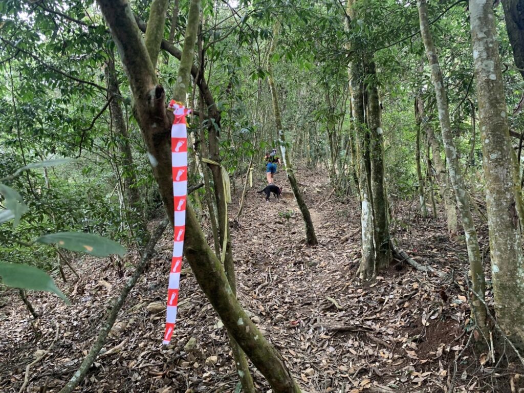
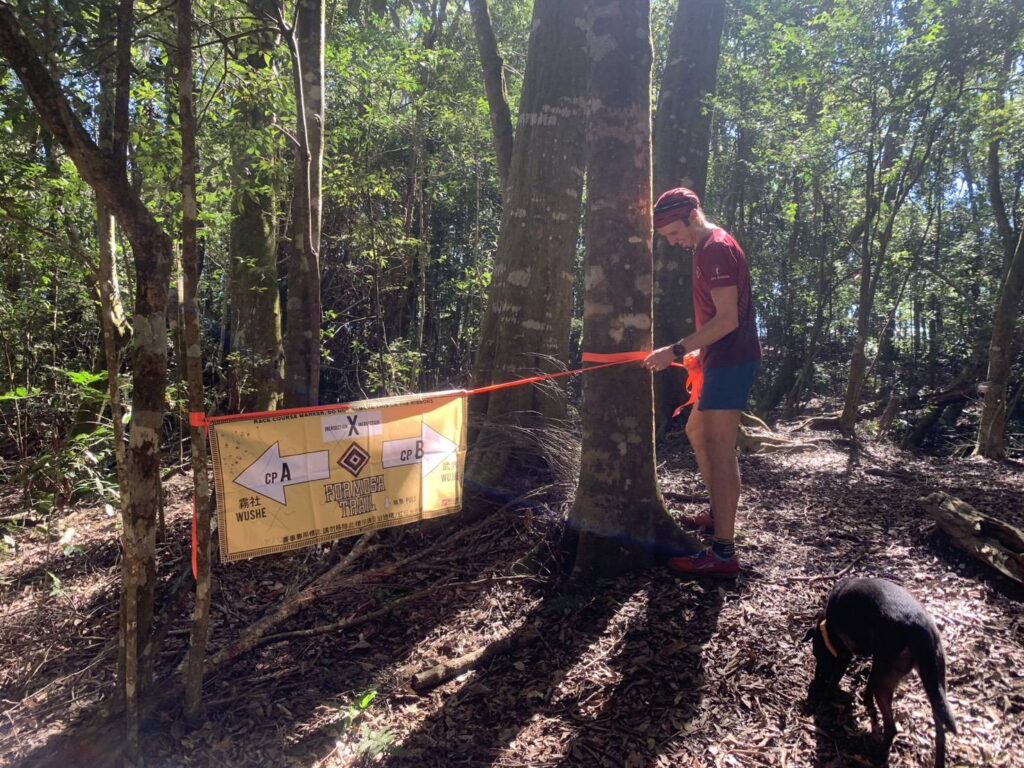
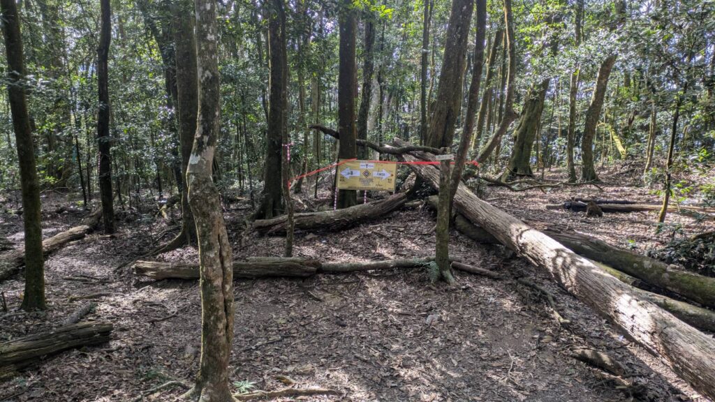
Official Course Markings
The official Formosa Trail course will be marked with BEAST RED/WHITE or ORANGE ribbons featuring REFLECTIVE stripes. Please note that other ribbons you may encounter are not official Formosa Trail markings, though they might help you stay on a general trail.
In addition to ribbons, we will use supplementary signage at important intersections (e.g., Intersection X, Y, Z or significant turns). At these points, you must navigate independently.
It is mandatory to have a GPS device with the course installed and to know how to use it.
There are numerous reflective TAGs along the course, visible with a headlamp. These TAGs are primarily placed leading to cpA1 and from 大尖山 Dajian Mountain to the finish line.
Important Places on the course
check point A
Tea Farm 茶園
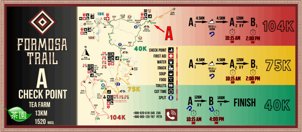
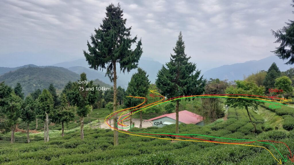
Check point A – Food & Drink
check point B
ORANGE house 橘子屋
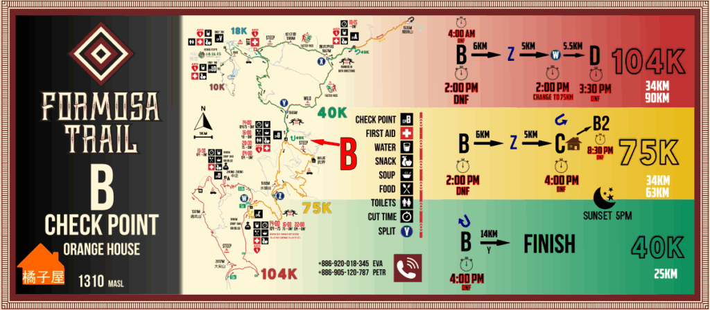
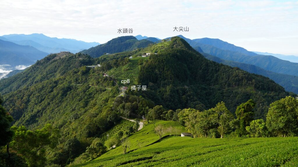
Check point B – Food & Drink
check point C
Forest House
(5km of forest road)
Check point C- Food & Drink
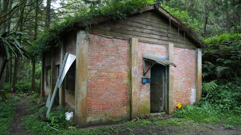
check point D
Zhong Zheng Churh
基督長老教會
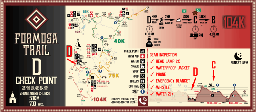
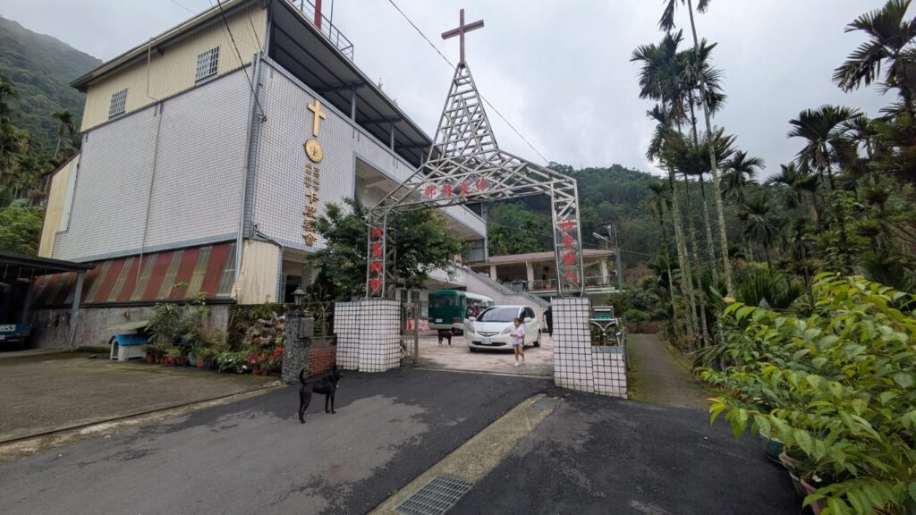
Check point D – Food & Drink
intersection X
intersection Y
intersection Z
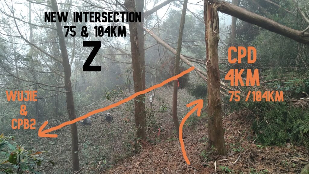
intersection W
200m from cpC
turn point 75/104km
關頭山
Important Places and their coordinates
YCC – cpA – cpB – cpC – cpD
Formosa Trail courses of 104km, 75km, 54km, 40km 18km and 10km. The beast trail running event in Taiwan.